How To Describe IELTS Maps


Table of Contents
- Overview
- Maps in the IELTS :
- Types of map questions :
- How to explain a map in IELTS Writing Task 1
- #Understand
- #Observe and compare
- Structure
- Language and vocabulary :
- Tips and tricks for scoring high in the IELTS maps task
- Sample questions and answers for the IELTS map question
- Sample question 2
- Practice questions for the IELTS map question
- Practice question 2
IELTS Task 1 Map: A Comprehensive Guide to Describing Maps
Overview
The IELTS Writing Section tests your writing skills using two tasks:
Task 1: You will be provided with a visual representation and have to describe it using a minimum of 150 words.
Task 2: You will be given a general topic. You have to express your views on the same with concrete evidence and examples.
Where exactly do the maps figure (pun intended)?
In Writing Task 1, of course.
The word map is usually used to refer to a 2-dimensional visual representation of a place—a diagram that shows the locations of various landmarks, routes, etc. Yet, maps need not always be so complex-sounding. Take, for example, the kind of map you doodle on a piece of paper to teach your friend the way to your house. That is a map, too!
So, a map can be pretty much any diagram that shows the locations of things in relation to one another, right? It could be a complex world map on an atlas or a simple map of a street using just boxes to denote various landmarks.
Now, what kind of maps can we expect in the IELTS?
Maps in the IELTS :
Maps, in IELTS, are simple outlines that depict
- the layout of a place (like a city, a town, a village, or even a street)
OR
- a created space (like a park, an apartment, a shopping mall, a school campus, etc).
These maps ALMOST ALWAYS come in pairs, or sometimes, as a set of three maps.
Their design is basic and easy to follow.
Types of map questions :
The maps question in the IELTS Writing Section usually features two maps of the same place, showing changes taking place over a period of time. Mostly, it is one of these three types:
- Maps showing changes in a particular place between two points of time in the past, for example, between 1980 and 1990.
- Maps showing changes in a particular place between a point of time in the past and then, the present, for example, between 2000 and the present.
- Maps showing the plans for development with regard to a particular place. Here, the time zones are located in the present and the future, for example, the present (2022) and 2035.
Why is it important to identify which type of the map question you get? The answer becomes obvious the second you start writing: Only if you know the time frame can you decide which tense(s) to use in your response.
Can you guess the tenses to be used for each type?
For the maps showing changes between two points of time in the past, you would be using the simple past tense, or a mixture of the simple past tense and the past perfect tense.
In 1980, most of the space in the town square was occupied by the department store. By 1990, it was demolished and a supermarket set up in its place.
OR
In 1980, most of the space in the town square had been occupied by the department store. By 1990, it was demolished and a supermarket set up in its place.
For the maps showing changes between a point of time in the past and then the present, you would be using a mixture of the simple past tense, the simple present tense and the present perfect tense.
In 2000, there were five farms stretched across the north-east part of the village. At present, there are only two farms in the area. The rest have been converted into commercial spaces.
OR
In 2000, there were five farms stretched across the north-east part of the village. At present, it can be found that the number of farms has been cut down to two, with the rest having been converted into commercial spaces.
For maps showing the present state of a place and plans for future development, you would be using a mixture of the simple present tense and the future tenses (the simple future tense or the future perfect tense).
At present, the apartment complex has only one building dedicated to common use, located towards the south-west corner of the premises . By 2035, a gym and a prayer hall will be constructed at the north-east corner and along the northern wall, respectively.
OR
At present, the apartment complex has only one building dedicated to common use, located towards the south-west corner of the premises . By 2035, a gym and a prayer hall will have been constructed at the north-east corner and along the northern wall, respectively.
Remember. You don’t necessarily have to use the tenses in exactly the same way mentioned above, as long as you appropriately describe the two time frames. Just make sure that, once you start writing using a set of tenses, you don’t keep switching in the middle of your response.
How to explain a map in IELTS Writing Task 1
How to explain a map in the IELTS Writing Section? It takes three simple steps to do that.
-
- Understandwhat the task requires you to do and what you are being tested on
- Observeandcomparethe given maps, and note down ALL the important features and changes you find.
- Organizeyour ideas into paragraphs and then begin writing!
#Understand
Before you attempt any task, it is crucial to understand what it requires you to do. The map question is part of the IELTS Writing Task 1, remember? So, let us first understand what Writing Task 1 is all about.
Writing Task 1, as we already saw, provides you with a visual representation that you have to describe in at least 150 words. It could be a chart, a table, a graph, a diagram, a process flow, maps, etc. The task direction is clear enough and goes something like this: “Summarize the information by selecting and reporting the main features, and make comparisons where relevant. Write at least 150 words.”.
It is clear that you are asked to DESCRIBE the visual representation and present the INFORMATION asked for. This applies to the map question as well.
What you MUST do:
- Follow the task directions completely.
- Explain what the maps show.
- Compare (relevantly) and describe the two maps.
- Mention ALL the important features.
- Mention ALL the changes (major and minor) AND things that have not changed.
- Support your points with relevant details from the maps.
- Write AT LEAST 150 words. You can write more, as long as you manage the time allotted (20 minutes).
What you MUST NOT do:
- Not follow the task directions.
- Leave out any part of the task directions, for example, comparison of the given maps.
- Omit mentioning some features and changes (This could lower your score).
- Add conclusions and interpretations of your own that are not supported by the maps.
- Draw irrelevant comparisons for the sake of making comparisons.
- Write less than 150 words.
#Observe and compare
Ask yourself these questions and make notes.
- What do the maps show?
- What are the time frames mentioned?
- What is the most prominent change between the two maps? How is it accomplished?
- What are the major and minor changes you can observe?
- Are there any additions to the second map?
- Has anything been removed from the first map?
- Has anything in the first map been replaced with something else in the second one?
- Has anything in the first map been enlarged or expanded in the second?
- Has anything shrunk in size?
- Has anything been relocated?
- What has stayed the same?
- Are all your comparisons and points relevant?
- Will you be able to support all your points with what is shown in the maps?
Now, all that remains is to #organize your response and begin writing. What is the best possible way to do that?
Structure
There are different ways to organize and structure your points into a good response. For example, you could organize your points by first covering one map and then the other, or mention important features and how they have or have not changed across the two maps.
Still, there are a few important pointers to keep in mind while planning the structure of your answer.
What are they, you ask?
- Make sure you give an overview to the maps at some point in your response, preferably at the beginning.
- Split your response into paragraphs.
- Have at least three paragraphs including an introduction, a body and a conclusion. Instead of the conclusion, you could also have a paragraph explaining the minor points.
- Make sure that each paragraph has an identifiable objective with supporting points and details.
- Check if the ideas flow smoothly between sentences and from paragraph to paragraph.
Here is a strategy that could help you organize your points effectively:
Para 1
- Include a sentence that explains what the maps show. This information can be obtained from the question itself. Just make sure that you express it using different words. This will not only showcase your writing skills but also clarify your understanding of the question.
- Make sure you mention the context and the purpose of the maps, if mentioned in the question.
- Provide a one-line summary that aptly sums up the most important changes between the two maps.
Para 2
- Capture the major features in the two maps and the major changes across the period of time depicted.
- Support your points with suitable details from the maps. Make sure you identify locations on the maps using clear landmarks.
- Write at least 3-4 sentences.
Para 3
- Capture the minor points and mention what has/have remained unchanged.
- Sum up your response with a suitable conclusion.
Language and vocabulary :
Apart from task achievement (content) and organization, language, and grammar to play a major role in determining your band score.
You would probably have a general idea as to how the scores for language and vocabulary are determined in the IELTS Writing Section. These are some important questions you should think of:
- Is your language academic and formal?
- Do you possess the sufficient vocabulary to bring in a variety of words into your response, rather than using the same set of words over and over?
- Are you using suitable words in the right places?
- Does your response have a mixture of long and short sentences, showing that you can easily switch between them as needed?
- Are you able to communicate the task requirements effectively to the reader?
- Leaving out occasional errors, is the response grammatically correct?
- Are there errors in your spelling and punctuation?
- What kind of grammatical range does your response showcase?
These points hold for the map question as well. Additionally, there are some other details you should pay attention to. We already looked at what tenses need to be used. What are the other aspects?
#Use the passive voice
Avoid using the active voice to describe the maps. Instead of “I can see that” or “We can see that”, write “it can be seen that” (passive voice). In other words, make the object of the action the focus of your sentence. Simple, isn’t it? And all of a sudden your response becomes much more academic!
#Include relative clauses
In simple words, a clause is a group of words consisting of a subject and a verb unit. Clauses are the units that come together to form a sentence. Relative clauses are groups of words containing relative pronouns like who, which, and that. These are used to either define a noun or add more information about it.
Why use relative clauses in a map’s answer?
As you describe the maps, it is important to specify features and locations accurately based on the map. And relative clauses are a great way to do that!
In 2015, the college gym, which is situated in the playground, only occupied a corner of it. By 2020, it had expanded to occupy almost the entire northern wall.
Relative clauses not only help you make your response as detailed as possible but also show that you are capable of using complex structures.
#Indicate directions
If the maps include a compass showing directions, use these to identify locations in the maps. For example,
In map 1, it can be seen that the girls’ washroom is located on the northeast corner of the main block.
The road crosses the village from the southeast to the northwest.
The northern wall of the park is dotted by trees and potted plants.
#Other ways to indicate the location
If there is no compass to identify the directions, you could always use prepositions and prepositional clauses to describe the location of any feature/item on the maps.
The cafeteria is situated across the street from the school.
A basketball court can be seen in the playground.
By 2020, a botanical garden had been constructed to the left of the main building.
A railway track runs parallel to the main road in the second map.
#Use synonyms
Synonyms are words that mean the same. Using synonyms, you can avoid using the same words over and over.
For example, instead of using the word located every time, you could also use:
situated,
positioned,
placed,
stationed,
occupied, etc.
#Use a variety of verbs
You are going to be describing a lot of changes that have taken place across the two maps. The following is a list of words to help you be specific about these changes:
Expand
Remove
Extend
Add
Narrow down
Renovate
Demolish
Build
Construct
Modernize
Develop
Set up
Widen
Replace
Can you think of other useful words to describe changes between maps?
Try to come up with synonyms as well for these verbs (for example, build and construct).
#Include transition words and phrases
Remember. You are not presenting isolated pieces of information. You are critically comparing a set of maps and presenting your findings in written form. So, your ideas need to be appropriately linked to one another. What better way to do this than to use transition words and phrases?
As the name suggests, transition words/phrases indicate the connections or transitions between words, ideas, etc.
The following is a list of transition words you could use.
- To introduce or add ideas show similarity: to begin with, firstly, in addition to…also, in the same way, just as … so too, likewise, similarly
- To oppose or limit: but, while, conversely, on the contrary, despite…
- To indicate causes and conditions: since, because of, while…
- To indicate effect and result: consequently, as a result…
- To support or give examples: especially, in particular, in other words, markedly…
- To conclude or summarize: to summarize, in conclusion, to sum up…
- To describe time: after, presently, now, at the present…
- To describe locations: besides, in front of, below…
This list is only to give you a general idea of how you can use transition words and phrases. Make sure you read more!
Tips and tricks for scoring high in the IELTS maps task
# Follow what the task asks you to do, accurately and thoroughly.
# Take a couple of minutes to observe the two maps thoroughly.
# Note the major and minor changes, and things that have not changed, separately. Include all the points that seem relevant.
# Take another couple of minutes to plan the structure of your response.Your response must be organized into paragraphs and contain an overview (a sentence covering the most prominent change) of the two maps at some point.
# Decide which tenses you are going to use and stick to them throughout the response.
# Use the passive voice.
# Use a variety of words in your writing. Do not look for complicated words whose meanings you don’t know. Instead, think of how you could bring in variety using the words you know.
# While describing what the maps show, use the technique of paraphrasing to express the information provided in the question differently.
# Be as detailed as possible while describing the items on the map. Include clear landmarks, directions, etc.
# Use words in such a way that you are as specific as possible in describing changes.
# Make sure that you don’t overuse either long or short sentences. Your response should be a mixture of the two. This will make it easier for the reader to follow.
# Stick to formal, academic language.
# Write at least 150 words.
# Revise your answer. Check for spelling and grammar errors, and ensure you avoid them to improve your score.
# Remember. Your task is to describe the two maps critically, supporting your points with details given in the maps. Do not make claims or conclusions of your own that are not supported by what is given.
Sample questions and answers for the IELTS map question
Let us now take a look at a couple of map questions and sample responses.
Sample question 1
You should spend about 20 minutes on this task.
The two maps given below show the layout of the kindergarten section of a school in the years 1990 and 2000, respectively.
Summarize the information by selecting and reporting the main features, and make comparisons where relevant.
Write at least 150 words.
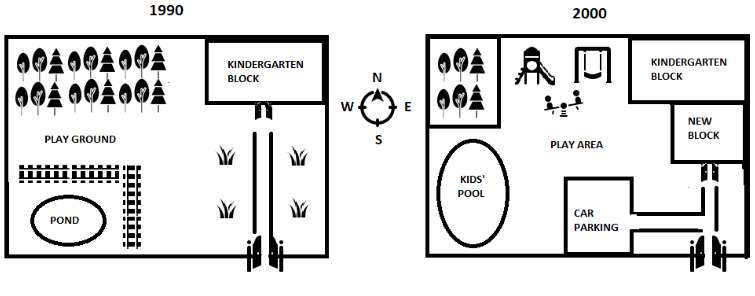
Sample response
The given maps show the changes implemented to the design of a school’s kindergarten section between the years 1990 and 2000. The most prominent changes seem to be the addition of a new block and the conversion of certain spaces into new utilities.
In 1990, there was just one kindergarten block located in the northeastern corner of the compound. By the year 2000, an expansion of the same can be noted, with the addition of a new block in front of and adjacent to the existing one. This, consequently, can be seen to have reduced the distance from the entrance to the kindergarten blocks.
Apart from the construction of the new block, it can be found that a lot of spaces were transformed into new utilities by 2000. The majority of trees located close to the kindergarten block in 1990 were cut down to make space for a slide, a swing and a see-saw.The fenced pool, which was situated in the south-western corner of the compound in 1990 was converted, by 2000, into a kids’ pool spanning most of the western wall and a portion of the southern one. In the space between the pool and the entrance, an enclosed car park was built.
Overall, across the ten year period, there was an enhancement in the extra-curricular facilities available to the kids, with the introduction of the play area and the swimming pool, and to the adults, with the setting up of the car park. However, these changes were accomplished at the cost of some things. From the first map to the second, a decrease in the number of trees can be clearly identified. Additionally, the sides of the path leading from the entrance to the blocks seem to have been leveled and the grass growing there removed. Most of the playground has been displaced by the swimming pool and the area redesignated as the play area. The maps do not clearly show if any alterations have accompanied this renaming. The only thing that has remained unchanged across the two maps is the placement of the entrance, which opens from the southern wall, directly opposite to the kindergarten block(s).
(Note: This response consists of 360 words. You need not write a response this long. However, also remember the only condition is that you should write a minimum of 150 words. There’s no upper limit. So, you can write longer responses if you are able to manage those within the time given.)
Sample question 2
You should spend about 20 minutes on this task.
The maps below show the main road in Farmshire village and the development plans for 2024.
Summarize the information by selecting and reporting the main features, and make comparisons where relevant.
Write at least 150 words.
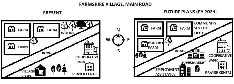
Sample response
The given maps show the present state of the main road in Farmshire village and plans of development for the same, intended to be completed by 2027. The main road traverses the village from the south-west to the north-east, and the two sides of the road, with farms, buildings, etc are depicted in the maps. Overall, the development plan seems to be focused on modernisation, to be accomplished by diversifying the occupational infrastructure available.
At present, the left side of the road consists of three farms, with a tree near one of them, and a woods area. The right side of the road, on the other hand, has a village store, a few trees, a cooperative bank and a prayer centre, the last of which is located a bit further in. These details make it clear that, currently, the occupational infrastructure in the area depicted is predominantly agricultural, along with other occupations like banking and sales.
According to the plans for development, by 2027, the occupational infrastructure will have been diversified further. The farm which is closest to the road on the left will be converted into a poultry farm. The village store on the right side will not only be relocated closer to the road but also developed into a supermarket. The cooperative bank will remain as it is, however, there will be the addition of an employment assistance centre, at the site where the village store is presently located.
Apart from the aforesaid alterations to the occupational infrastructure, there are a couple of other noteworthy changes. The woods positioned to the left of the road will make way for a community soccer field. In this area, as well as on the right side of the road, trees will be cut. Nevertheless, trees will also be planted near the road on the left side, though not on a similar scale.
Practice questions for the IELTS map question
Did you observe the different ways in which the two sample responses approached the respective questions?
Go back to our detailed discussion and then the sample responses. How have the responses incorporated and played with the strategy and the tips?
How would you have answered the questions given above?
Take a minute to process all these thoughts.
Are you now ready to attempt IELTS map questions on your own? Here are a couple of practice questions for you!
Practice question 1
You should spend about 20 minutes on this task.
The maps below show the layout of Lakeview Apartments in the present and development plans for the year 2030.
Summarize the information by selecting and reporting the main features, and make comparisons where relevant.
Write at least 150 words.
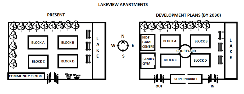
Re-visit your response and evaluate how far you have succeeded with respect to following the task directions, organising your response, following the minimum word count, language, grammar, etc.
What have you done well? What needs to be improved?
With these points in mind, attempt practice question 2.
Practice question 2
You should spend about 20 minutes on this task.
The maps below depict the industrial area of a town in the year 2000 and the present.
Summarize the information by selecting and reporting the main features, and make comparisons where relevant.
Write at least 150 words.
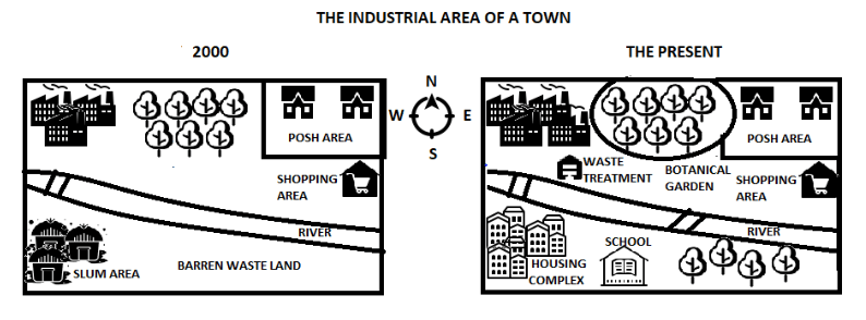
Done? There you are!
Aren’t you now quite a “pro” in the maps question type?
Want to know where you stand? Take a free full-length IELTS mock test to get an instant band-score estimate before exam day.
Related tools & resources: IELTS band calculator
Ready to practise under real exam conditions? Take a free IELTS mock test.
Build confidence before the real exam by taking our IELTS practice test.